Home | Front Page | Blog | Index | New | Contact | Site Map
Maps |
Pics
Elizabeth Bay
Opera House
CBD - Downtown
Bondi - Coogee
Beach Scupltures
Buying Bicycles
Scottish Festival
University of Sydney
Carols on the Domain
Sydney-Hobart Race
Watson's Bay
New Year's Eve
Sydney 2006-07
South East 2007
Melbourne 2007
South Aust 2008
Ayers Rock+ 2008
Darwin+ 2008
North East 2008
Travel 2007
Sydney
Paris
Britain
USA
Canada
Australia 2007-08
Travel 2006
Greece
Turkey
Thailand
Malaysia
Indonesia
Singapore
Travel 2005
Berlin
Paris
Moscow
Russia
Athens
Sydney, like so many things, is a name that covers many things. To the locals, it can mean just the historic center. We, living just two kilometers away, are in Elizabeth Bay, and we have Darlinghurst and Wooloomoogong, all considered "non-Sydney" lying between us and the C.B.D.
But if we were to take a more expansive view Sydney is everything within an hour's commute of the C.B.D. or it is everyplace that uses the Sydney international airport as its "primary airport." Or to take a geographic view, Sydney is a coastal plane boxed in on the west by the Blue Mountains and on the east by the Pacific Ocean. By this latter view Sydney streches about 115 kilometers north to south and 60 kilometers east to west. This area, about 6000 sq kilometers (2300 sq miles) is about the same size as 1/3 of Israel or New Jersey. It houses about 6 million people, just under 1/3 of Australia's entire population of 21 million.
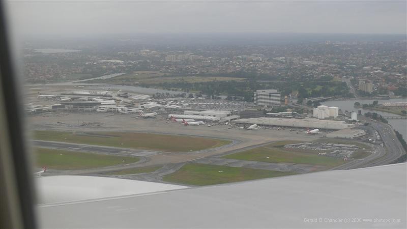
Over Sydney Airport, looking south away from center |

Sydney Airport terminal buildings
|
The First Fleet arrived in Botany Bay in 1788 and the expedition leadership immediately concluded it and its shores were far from suited to being the center of their planned penal colony. Captain Arthur Phillip, first governor of New South Wales, sent out search parties to find a better place. He and they were delighted to discover Sydney Harbor just 10 kilometers north and decamped there within a few days. Today Sydney's international airport is situated on the shores of Botany Bay and, in fact, its runways extend into it. (This was obviously done before the modern concern with saving wetlands.) From the airport the skyscrapers of central Sydney are visible.
Sydney Harbor is in fact the broad estuary of the Parramatta River which rises in the west. The shape of the river/harbor is familiar to us, having lived so many years near New Jersey's Swimming River, which when it is broadens, is called the Navesink. Both Sydney Harbor and Navesink run generally east-west, with their oceans on the east. The Sydney basin, at 17 km far outdistances the Navesink, about 10 km. That is not the only difference. In New Jersey we can sometimes iceskate on the Navesink; that never is possible in Sydney. Besides the cold it is the shallowness of the Navesink that allows it to freeze; Sydney accommodates the largest ships because the harbor is deep.