Home | Front Page | Index | Blog | New | Contact | Site Map
Prague Intro
Old Town
Charles Bridge
Castle Hill
Josephov
North-East
Wenceslas Square
Vysehrad
Vltava
Foto Show

Egypt
Israel
Turkey
Bulgaria
Romania
Ukraine
Poland
Prague
Britain
USA 2002
Travel Map
Prague is a city of about a million people whose historic center, containing less than a tenth of its area and population, is located on the banks of the Vltav River. It was created in 1784 by uniting under one administration its historic components: the Old Town, New Town, and Josephov (all on the east or right bank of the Vltava) and the Lesser Quarter and the Castle Complex (both on the west or left bank). Of course all of these areas are much older, going back to settlements by Slavs in the 5th and 6th centuries.
The Vltava is a rather short river, only about seventeen miles (28 kilometers) long; in this space it averages a bridge almost every mile; the average is far higher in old Prague. The Vltava ends its short life by flowing into the Elbe River which then leaves the Czech Republic and flows into Germany. Just across the border, about 90 miles to the north north-west is Dresden, through which the Elbe passes and then goes on to the Baltic Sea.
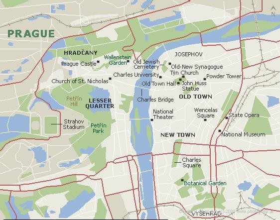
Prague Map with names in English |
Historic Prague is a wonderful place in which to walk. The distances are not vast and around every corner there is a new surprise and a new delight.
A great way to get acquainted with the city is to take a walk that starts near the Old Town Hall, and the John Huss statue, goes west through romantic streets to the Charles Bridge , crosses the Vltava, passes through the Lesser Quarter, and heads uphill to Prague Castle, and St. Vituss Cathedral.
This walk, in its entirety, is just under 1.5 miles (2.5 km). A fast walker can do it in 30 minutes. Stopping to visit and savor all that is found along the route could take three days.
While a great introductory route, or one that can be used if time is very limited, this walk doesn't do full justice to the city. It leaves out Josephov, the historic and very interesting Jewish district; Wenceslas Square, now the equivalent of Oxford Street, Fifth Avenue, or Rodeo Road for Prague; and the Vysehrad promontory, one of the most neglected, most historic, and most interesting areas of the city.
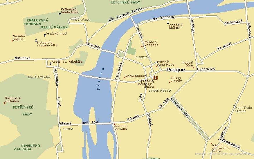
Praha Map with names in Czech |
One little problem in learning about Prague is the question of naming: some maps and books give names in English; others in Czech. Initially it can be confusing and one might not realize that the same bridge or river has been mentioned under the two different names rather than there being two different places.
The Charles Bridge, ordered constructed in 1357 by Charles IV, the Holy Roman Emperor, is also know in Czech as Most Karly. The Czech word for bridge is "most" and Charles translates into "Karly". The Old Town, start of the proposed walk, is called in Czech Staré Mesto where stare=old and Mesto=town. The Lesser Quarter, across the Vltava and the Charles Bridge, is known in Czech as Mala Strana, where mala=small/little and strana=quarter/district. Czech for castle or fortress is hrad. Thus the Prague Castle is also known as Prazsky Hrad or simply Hradcany (The Castle) and the older fortess on the right bank as Vysehrad. Good King Wenceslas is called Vaclavske and Wenceslas Square is known as Vaclavske Nam. Because Czech is a slavic language these words are very similiar to the equivalent Russian: bridge=most; old=stare; town=miesto. And finally, Prague is known to its citizens as Praha.
Now let's take our mile and half walk from the main square of Old Town (Stare Mesto) over the Charles Bridge (Most Karly) through the Lesser Quarter (Mala Scala) and up to Prague Castle (Hradcany) . Afterwards, if you have time and energy, go on to Josephov (the old Jewish quarter), North-East of Old Town, Wenceslas Square, Vysehrad Castle and Park, and a walk along the Vltava River