Home | Front Page | Blog | Index | New | Contact | Site Map
Sonora Impressions
About Sonora
Mission Trail
The Sting of Sonora
NuevoLeon
Coahuila
Chihuahua
Sonora
Durango
Jalisco
Sinaloa
Zacatecas
San Luis Potosi
Queretaro
Guanajuato
Michoacan
Guerrero
Morelos
Puebla
Tlaxcala
Oaxaca
Chiapas
Campeche
Yucatan
Quintana Roo
Teotenango
Xochicalco
Monte Alban
Mitla
Palenque
Uxmal
Chichen Itza
Tolum
Belize Mayans
Tikal
Copan
General Topics
Churches
Beach Bumming
Swimming Along
States
Websites
Map
Car Costs
> USA-Britain
USA 2003
USA 2002
Britain 2002
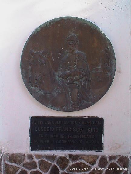
Sign Commemorating Father Kino |
A main goal in coming to Sonora was to visit the sites of missions founded by Padre Eusebio Francisco Kino. Of Ital. n origin, in 168, at the age of 37, he came to Mexico City. A year later Padre Kino was assigned to live and work in Primeria Alta, the old Spanish name for what is now most of Sonora and southern Arizona. (See The Primeria Alta: Missions and More, edited by James Officer, et al, 1996 and A Kino Legacy by Charles W. Polzer, 1997.)
Over the course of his life Padre Kino did his missionary work and made major contributions to the mapping of the area. It was a nice coincidence for us to learn that it was Kino who discovered that Sir Francis Drake was wrong in thinking California was an island. Apparently Drake had sailed up the Gulf of Calfornia without reaching its head (perhaps due to the heat or lack of winds), retreated, and continued up the west coasts of Baja California and California to what is now Drakes Beach in Point Reyes National Seashore (which we visited at the end of May). Apparently the cold of the north made him turn back without finding the end of his "island". Kino in the 1680s and we today had seen the shore and knew that a continuous land route connected Sonora to . CaliforniaHere is his description:
Kino's description of the Sonora-California land route:
In general, in these twenty-one years, up to the present time, I have made from the first pueblo of Nuestra Señora de los Dolores more than forty expeditions to the north, west, northwest, and south west, of fifty, eighty, one hundred, two hundred, and more leagues, sometimes accompanied by other fathers, but most of the time with only my servants and with the governors, captains, and caciques of different rancherias or incipient pueblos from here and from the interior.…
But Drake is very much in error in his fabulous demarkation, in which he very wrongly depicts California as an island, saying that its sea extends up to the Sea of the North and the much talked of Strait of Anian, for in these ten years, in fourteen expeditions which I made for this purpose, we have plainly discovered that this Sea of California extends no farther than to thirty-four degrees and a half of latitude, where there is plainly a passage to California. By it there continually come to us many of those blue shells which are produced only on the opposite coast of the above-mentioned California and South Sea, whereby every year the ship from China is accustomed to come.… Microsoft® Encarta® Reference Library 2002. © 1993-2001 Microsoft Corporation. All rights reserved.
While in Tucson we had made an excursion south along the Santa Cruz River to visit missions San Xavier de Bac and San Jose de Tumacacori. From these visits we had learned of Padre Kino and been inspired to learn more about this man and see his work in Mexico. We were fortunate enough in Tucson to pick up a brochure from Kino Mission Tours ( http://www.smrc.missiontours.com ) with a map that indicated nine different missions that could be visited in Mexico. One was in Caborca and that is why we made it a destination.
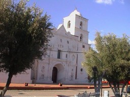
San Pedro y San Pablo de Tubutama |
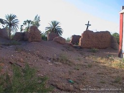
San Francisco del Atil |
Late in the afternoon of our stay in Caborca, we drove 20 miles east to the town of Altar and then headed north, back towards the US border, following the Altar River and its valley. As it turns out the Sonoran desert is also called Desierto de Altar by Mexicans. Kino and others considered the desert to start north of Altar. True to its old name, as we drove the territory became more and more desert like. The population along the route is very low and the villages, all small, are quite spread out, at least 10 km from one to another. So, excepting for climate changes, we perhaps saw things as Kino might have, going along on his horse more slowly than our horseless carriage. As on our route south from Sonoyta there were plenty of saguaros and from time to time big fields of organ pipe . cactusThe mountains in the distance appeared in wonderful shades of purple as the sun was already low.
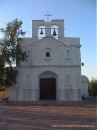
San Antonio Paduano del Oquitoa |
At Tubutama, our northernmost point for the day, we saw mission San Pedro y San Pablo de Tubutama, a handsome and much restored building. A 1937 photograph that we saw later in the Hermosillo museum shows it unplastered and unwhitewashed. It was closed because it was late in the day, so we didn't get to see the inside. After a walk around we left the small village and headed south for Atil. There we saw the remains of San Francisco del Atil, just a few mud walls, now unprotected and uncared for. It was obviously small compared to Tubutama and, we suppose, compared to the needs of the local people. Adjacent to it are a new chapel of 1941 and a still newer, nice church of 1998. Back we went south, admiring again the organ pipe cactus and ocotillo, to San Antonio Paduano del Oquitoa. On top of a hill above the modern village sits a very restored and modernized building with little about it to tell you that it may have been connected to Kino and Spanish colonization. We walked around a bit, inspected the graveyard (where several men were picking away at the hard earth to cut a new grave, although it was well past normal quitting time) and started our return to Caborca. We skipped visiting Altar because it was nearly dark; once in Caborca we got lost because it was dark and we were on a detour route due to the construction.
La Purisima Concepcion de
|
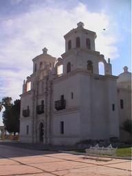
The next morning we visited mission La Purisima Concepcion de Nuestra Señora de Caborca. This has been beautifully restored, with a large plaza created outside of it surrounded by a colonade. We didn't get to see the inside because we were there too early. We spent a few minutes driving around Caborca and saw that it is a rapily growing town. Now it has about 70,000 people. In the center it is all paved, there is a very modern supermarket, and several semi-fancy motels and restaurants. On the outskirts, in the growing parts, the streets are unpaved. Sometimes alternate streets or even alternate blocks are that way. But, it seems that the worldwide trend of moving from the countryside to urban areas is very much at work here. Just as we found our insurance adjuster here, others come to this market down for what they need. For example, later in the day in Altar we spoke to a boy who sold cold drinks from a tricyle outfitted as shop. He had come to Caborca to buy it.
After reloading our car with the trunk and a half of things we carry about we checked out and left town for Altar by Mex 2. It is undergoing reconstruction and for a kilometer we drove a rutted dirt lane well below the grade of the adjacent right of way that was about to be paved to modern standards. We'd followed this path the afternoon before and knew what we were getting into as far as the quality of the road (though then we'd had to ask a passing police man if it was safe to go ahead).
Parish church in Altar |
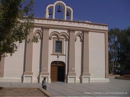
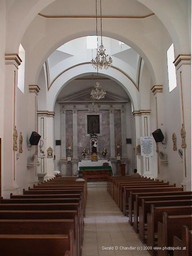
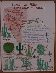
In Altar we stopped at the old church, but it was not one associated with Kino. Nonetheless it proved interesting. Inside one wall had several posters telling potenital illegal immigrants about their rights if they were picked up in the USA. One of them, repeated on several posters, was that they were entitled to pay for what ever work they had already . doneAnother was that minor children could not be taken away from them. On the opposite wall the theme was quite different. The poster said "Vale le pena arriesgar tu vida?" ("Is it worth risking your life for?"). The reference is to the high chance of dying in the desert while trying to cross illegally into the USA. The local paper published a toll for the last several years; about 20-30 have died each year. When going to Tubutam if we had continued on all the way north to the US border we would have come to a favorite place of illegal immigrants to cross. There is comparatively little human traffic north of the border and much desert, giving them, it seems, good hope that they can walk in unobserved. But, as the church posters indicated, all too many need a rescue as the falter under the hot sun and lack of water.
Inside Altar Church
|
Admonishments to Would-be
|
It was in Altar that we met the boy with the iced-drinks tricycle. His little brother, of about 8-9 started following Gerry. When Gerry sat down to await Jan who was still in the church the boy started a conversation. Gerry was quite happy because it was good Spanish practice for him. Then his older brother with the drinks came by and they talked. The older brother asked for English language peridodicals. The reason seems to have been to give him something to practice his English on; or perhaps there is a market for them and he wanted a little extra income. In either case he should be happy as Gerry gave him our recently read second-hand copy of Robinson Crusoe.
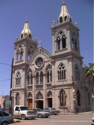
Parish church in Santa Ana |
From Altar we went on another 45 miles east to Santa Ana. The route became lusher and lusher. It certainly did not belong to the Desierto de Altar. Our intent had been to take a motel in Magdelena, the town 11 miles further north where Kino died when he was there to inagurate mission Santa Maria Magdalena. But seeing from afar that Santa Ana had a big church of its own we turned off the main highway to visit it. The town was big enough for a supermarket, but much smaller than Caborca. Its church is attractive, but 19th century rather than 17th century. All the streets we saw are paved. Right through its heart runs the north-south railway that connects the port of Guymas on the south to the border town of Nogales, Mexico on the north. While in Phoenix we read a proposal to use this railway to bring large aviation parts to a proposed Boeing plant in Phoenix. Certainly there seems to be capacity on the line. While in Santa Ana we saw one train go through. This low rate is rather unlike that we saw while crossing northern Arizona. There the Sante Fe Burlington Northern line had a train going by every five-six minutes. Today Santa Ana takes a minor role in life compared to its bigger neighbor, Magdelena. But 200 years ago that was not the case. Then, when under economic pressure the presidio at Tubac was closed, and the colonizers in its surroundings suffered increasing waves of attacks from Apaches, they retreated to this Santa Ana, where they found a safer life and less harsh environment.
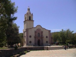
Santa Maria Magdalena |
From Santa Ana we set off north to continue our Kino trek.This time we would visit as we went, rather than going to the end and coming back. If we found everything we would see four more missions over a range of 50 miles. Our first stop was Magdelena which was as expect cosiderably bigger than Santa Ann but no match for Caborca. In most places the church towers rise over everything nearby and thus can be seen from a long distance; as we approach town or village we easily determine where to go. Such was not the case here, partially because the town is on the slightly undulating slopes of the Santa Ana river valley and partially because there are several churches. We asked directions to the Kino church and followed them to a impressive church. It may or may not have been Santa Maria Magdalena; we had our doubts because there was nothing for or about Padre Kino and there was a side chapel devoted to Saint Francis. We watched people come in and kiss his prone statue, obviously in the hope of some cure or problem being solved. Across the streets, unlike anyother church or mission we visited in Sonora, there were covered arcades selling tourist trinkets and devotional objects, many with a relation to San Francis.
This ambiguity whether we had found the mission fits right in with the late attention paid in Mexico to Padre Kino. He seems to have been mostly forgotten until he got attention in the USA for his connection to missions San Xavier de Bac and San Jose de Tumacacori. With a little embarrasment the Mexican government asked where lay the bones of this national hero. They created a search commission and in 1984 it easily determined that he died in Magdelena. Some bones were dug up, examined, and declared to be his. We thought there would be a marker noting all of this. But since we didn't see it perhaps we were given wrong directions.
On we went north to Imuris in search of mission San Jose. At the junction between Hwy 15 and Hwy 2 we turned east, thinking that was the way to the center of town. But in fact we were in the newer part of town, as evidenced by dirt streets and the growing number of shops along along a three mile segment. One of them was an Oxxo convenience store; we stopped there because it was on the edge of town and we had obviously missed mission San Jose — no white towers pointing skyward had been visible. As we started to go in a little girl came out and spoke to us; although we didn't understand her, we quickly learned her message when we went in: the store is not open yet. Inside were half a dozen people installing cases, doing final clean up, etc for what would soon be the grand opening.
Oxxo stores like these are everywhere in the larger towns and cities. Another sign, along with cell phones, of the modernization of Mexico. They are alike in size and layout to the 7-Eleven and Circle-K stores that are so familiar to us in the USA. We were rather surprised at first that neither of these brands are present in Sonora, given that you do find in Hermosillo McDonalds, Carl Jrs, KFC, and Pizza Hut. Then, when we did see a solitary Circle-K that surprised us.
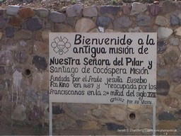
At the Oxxo we were told, yes, we had missed mission San Jose. It was in the center of town, on the other side of Hwy 15. To save a bit of travel we decided first to go on to mission Nuestra Señora del Pilar y Santiago de Cocospera if was not too far. Its distance was not marked on our map. How far, we asked, is it to Cocospera? Some heads turned to each other and gave a consensus answer: about 15 miles. That seemed not too much, so we set off on Hwy 2 for what was the farthest mission for us.
Hwy 2 seems to follow the northern Mexico border as closely as economically is reasonable. It runs from Tijuana in the west to Cuidad Juarez in the east, about 700 miles. Its two lanes and rural character makes us think of how old US 66 or US 60 were when they were in their prime as major east-west routes in the USA. In Santa Ana our motel was a block from the bus station; we saw several packed buses depart for Cuidad Juarez. Our way along Hwy 2 climbed very sharply over the next 8-9 miles along a curvy road. And then it descended almost as fast. It was beautiful country that seemed lush compared to the true desert we had been in for weeks. In reality it was only comparatively lush and far from an eastern forest or green English sheep country.
Sign to the Cocospera Mission
|
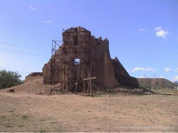
Nuestra Señora
|
When we had gone more than 15 miles and made an ascent, a descent, another ascent, and another descent, we wondered if we would find the place. But, just as we were about to give up we came to a road sign: Cocospera. But it was a sign without a village. There was a ranch alongside the road with a few cattle buildings, but no mission. We stopped and looked and looked and waited. Finally a man appeared but he was in no hurry to come over to us from behind his fence. When Gerry opened the gate he came over and told us that the mission was another three miles.
What a beautiful site it turned out to be. On a small rise above a broad valley, the site has a wonderful openness to it. There we could imagine the wind and fresh air and sping green inspiring many a service. If we could have a home in that spot, and perhaps own the ranching country around it, wouldn't we be delighted! But only the shell of the mission remains. The walls are mostly there but the roof is entirely gone. One is left to imagine the interior once had a splendor like that of San Xavier de Bac. We suspect that the village that must have once been around Cocospera just faded away. Hwy 2 is a difficult route and there would, until the last 30 years, have been little traffic on it unlike Magdelena and Santa Ana, which are on the major route from the USA to Hermosillo and south.
Having seen the shell of the Cocospera mission, we retraced our steps; we climbed and we descended and we enjoyed the greenery and the cattle country that are part of the Sonoran plains. We got back to the Oxxo store and went on and crossed Hwy 15 and found the old center of Imuris and mission San Jose. Here we had no doubt that we were in the right place because there was a large round plaque in memory of Padre , Kinoidentical to one we saw at Tubutama. The mission itself is rather plain and uninteresting, having been much restored, with unromantic uniform plaster and no nice architectual details.
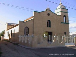
San Ignacio de Caborica |
We were halfway back to Santa Ana when we saw a sign for the village of San Ignacio and remembered there was one more mission on our list: San Ignacio de Caborica. We turned off and headed west along a small local road. After two miles of gentle curves we came to the edge of San Ignacio village. It lies on both the railway and the river where they and Hwy 15 momentarily part ways. Before we got to the village we saw the towers of San Ignacio so we knew it would be easy to complete our journey. But in the village the paved road ended and we had to make our way though a tangle of dirt streets. We did that and found one of the larger, better preserved missions. A handsome whitewashed building with a nice tower.
Opposite it was the usual village square and on the other three sides of the square were the remnants of a carnival obviously held that day. Several rides offered Disney characters such as Mickey and Pluto. Other stands offered carnival food, with a Mexican twist. We see from the calendar that Sonora's schools start classes August 18. Could it be that the traditional end of summer in these parts includes a visit from the traveling fair? It might be; we also saw a circus set up outside Caborca and a smaller one near Atil.
Having missed the carnival we made our way back to Santa Ana through Magdelena. In passing through we saw another church. Could that be mission Santa Maria Magdalena? We didn't have the energy to go find out. The next day we gave up the comfort of our new room in Santa Ana for the unknown of Hermosillo. We drove straight south on Hwy 15, about 100 miles. Again the country was flat; the mountains were fewer or farther away. As we went the nature of the country side was still dry, and there were still cactii, but it was simply less of a harsh desert.
