B |
eaches and Barrancas |
September 18, 2003 |
|
Home | Front Page | Index | Blog | New | Contact | Site Map 
We got to Sinforosa from the nearby town of Guachochi along a dirt road transformed into a mudbath by heavy rains the previous evening. . e drive took an hour and was pretty hair-raising. Jan was happy to be sitting in the back seat for a change to make room for our two Swiss friends, Sandro and Yvonne, who had taken a day off their bicycles which they are planning to ride all the way to Chile. We found more mud on the trail down into the canyon, but by the time we climbed back up the 300 meters from our lowest point the mud had hardened.
Year In Review
(2002)
Jan's Resume
Virginia
Egypt (Jan, 2002)
Vietnam (Feb-May, 2001)
Paris 1999 Top |
After many delays we crossed again into Mexico on August 1 and began a return trip to three northwest states, Sonora, Chihuahua, and Durango, visiting over seven weeks sites that we had missed on our first, rapid trip through these states in April.
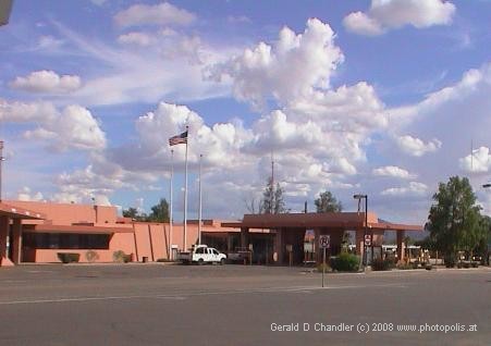
We crossed the border into Mexico in the late afternoon at the small Lukeville-Sonoyta crossing. On the Mexican side we were very happy to find a friendly border official who helped us fill out the forms and even helped us give the right answers to his questions. Our suspicion is that he was very accustomed to dealing with American and Canadian snowbirds going through on their way to their winterhaven at Puerto Peñasco. When we told him we were going all the way to Guatemala, he recommended against putting that down on the form because if we did he would have to give us a transit visa for only one month rather than the tourist visa for six months that we wanted. It was too late in the day to go on, so we got a room and the next day went on to Puerto Peñasco. This started our exploration of the Sonora desert, a southern continuation of the Arizona desert, and the next two days we continued it by following the trail of Father Eusebio Francisco Kino to a half dozen of the missions he founded. By the time we got to Hermosillo, the first real city since Tucson, we had a true appreciation of Father Kino and his missions, a yen for some cool, cool, water in which to swim, and a broken passenger door window, acquired our night in Puerto Peñasco. We easily got the window fixed, found a great hotel pool in which to escape the scorching summer heat, which hovered around 40°C (100°F) during our stay, and had time to catch up on our diary. From Hermosillo, we made a brief excursion to two of the beaches of Sonora — Bahia de Kino and San Carlos. At San Carlos we had 12 hours of panic followed by resignation when Gerry could not locate his wallet. It turned to relief when it was discovered in a hidden reach of the trunk, hidden and forgotten, when we took a guided kayak tour through the bay.
A short visit to Alamos an old silver-mining town, now colonized by Americans who have restored old haciendas, became shorter and more memorable by a sting. If that hadn't spoiled our pleasure in Alamos, the heat, the insects, and the lack of life would have; we guess others know what they are doing when they make April the most popular month. We sent a write-up of Alamos experiences and an earlier tire blow out and broken window to lots of friends and apparently it gave them the wrong idea and got them thinking we didn't like and weren't enjoying Mexico. We got to Alamos when we did as a result of a last minute change of plans: Originally we thought to go inland, and then make a return to the coast that would take us to Alamos and then allow us to continue south along the coast to Mazatlan. But some calculation showed we could save 300 miles by re-arranging our order of visits. And we could sooner leave the heat and humidity behind. As we climbed the western reaches of the Sierra Madre Occidental, as we went from sea level to nearly 5000 ft (1500 m) we gradually left behind heat and cacti. Nonetheless, when we rounded one bend on the Hermosillo-Chihuahua highway and realized we were in a true pine forest we were astonished; we felt that we knew what it was like for a desert dweller to dream of a watery and green paradise.
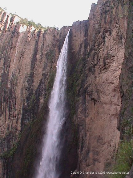
We were on our way to two sights, one important and the other must-see, that we had narrowly missed in our first visit to Chihuahua. Then we had less than a week in the state and had not wanted to be rushed through them. The first stop, impressive, was the Basaseachi waterfall. It is well worth a stop, although not worth a long journey. But the second, the must-see sight, proved to match its reputation. Copper Canyon, or la Barranca del Cobre. Over a week we saw about half of the eleven canyons that make up this high, cool, green, and very beautiful area. The canyons don't have the stark grandeur of the Grand Canyon, and it is hard to find a viewpoint that can give you a true impression of their enormous size, but in their own way, they are unforgettable. We hiked and gawped, gawped and hiked, basing ourselves in the small tourist-oriented town of Creel. One great surprise to us was the number of Tarahumara Indians in costume on the streets of Creel and in the surrounding areas. We had first heard of them at the Phoenix and Tucson Indian museums we visited. They have largely retained their traditional ways to this day. When we walked through the countryside around Creel and saw them we were reminded of the costumed Hmong and Black Tai that we saw in northern Vietnam. From Creel we went on through more majestic canyons to the high plateau where Guachochi is located and saw the most beautiful of all the canyons, Sinforosa . We shared our visit with two Swiss bicyclers that we had first met outside of Creel. Then we made a return trip to Parral, whose domed church can remind you of Florence, Italy. It was in Parral that we realized how much better our Spanish was getting. We had been reading the newspaper in Spanish everyday and simple books (e.g. a western written for kids) but did't realize that our listening comprehension was also making lots of progress. But we reasonably followed our Spanish-speaking guides to old La Negrita mine one day and the next to the Alvarado Palace.
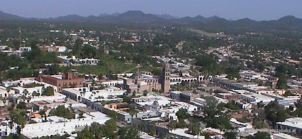
This is as good a point as any to mention how we were following Mexican and World events, since at the date we are writing this it is hard to remember exactly what,when, or where we read something. Mostly we depended on Mexican newspapers, getting familiar with a new one every few days. Once in a while we had CNN en Español and almost never had CNN or other English-language media. One event we know precisely is Presidente Vicente Fox's report to the Mexican nation; we watched it televised live on September 1 in our room in the small town of Guadalupe y Calvo, starving because we put off dinner. When the European Union said some bad things about Castro's dictatorship in Cuba that got lots of coverage, some of it very supportive of Castro We got plenty of news about the September 11 anniversary of the terrorist attacks. Day after day 3/4 of the opinion writers said something nasty or gloating about the United States. And we gradually got to know and follow some of the scandals, corruption, and other local/national matters in the Mexican press. Going on, we went south, mostly on a high plateau/prairie landscape towards Durango. Shortly out of Parral, we made a stop at the last home of Pancho Villa, the hacienda Canutillo that he managed until he was gunned down in Parral in 1921. This stop, worthwhile in itself, caused us to drive a last, scary hour in the dark before we entered Durango. In Durango we took another city-break to enjoy western (as opposed to Mexican) food again and to take time to enjoy the culture and architecture of this old colonial city and revel in its wonderful climate. We discovered gorditas and that we liked them and we gave up, perhaps for all time on frijoles. We lingered long enough to see and help celebrate the night of the "Grito", Hidalgo's 1810 cry for Mexican Independence. We stayed so long, 12 days, that we were able to catch up on some of those things that really must be done every once in a while. We found a dermatologist who confirmed that Gerry's facial basal cell carcinoma had cleared. And he recommended a terrific dentist who cleaned our teeth and replaced several fillings for Jan. We went through the hassle of several hours calling the USA collect and got all of our bills paid and credit card accounts up to date. We also had a sort of "deja-vu all over again" experience: our Fosa notebook had gone dead and we found a terrific repair man, just as we had in Edirne, Turkey . While trying to find the post office we stopped a woman who turned out to be a Mexican-American retired to Durango; Margaret invited us to tea at her home and we had a chatty afternoon getting to know the town and her finances from her. Hopscotching from one part of Mexico's mountains to another during this trip has really made us fall in love with mountain living again. Mexico's mountains are perhaps more beautiful even than its beaches. They certainly are less well developed touristically speaking, and perhaps therein lies some of their charm.
From Durango we drove towards the coast through charming high valleys and then on perhaps the most spectacular of the many spectacular mountain roads in northern Mexico. Called the Devil's backbone, it follows a ridge for part of the time with sheer drops on either side; from Durango's 8,000 feet it winds down, and around, and down, and around, until just when you think it can't go down any further, it does! And then the "point final", the expected but unexpected twist: we crossed the Tropic of Cancer and were really in the south: not the South of England, not the American South, but the South of North America and of Mexico. We paused here, just over the border from Durango State into Jalisco state, before going on to Mazatlan, the Mexican jewel of the east side of the Sea of Cortez. That, and points to follow, will be the subject of our next Frontpage. |
|
Some simple mathematics can result in some suprises. The first surprise comes from this question: If you go one degree south, how many miles or kilometers is that? If you start at our furthest northern point, Petaluma (near San Francisco) and end up where we are, what percentage of the distance south to the equator have you passed? The earth is 24,000 miles (40,000 km) in circumference and has 360 degrees around the equator and in a circle around the poles. Thus one degree corresponds to 66.66 miles (111.11 km). And thus we get to the first surprising part: if you travel 66 miles south you have passed through one degree. If you start 38 degrees north and travel 66 miles south you have gone 1/38 of the way to the equator. Our furthest north point was Petaluma, which is at 38.25°N (degrees north). San Franciso is at 37.25°N, the Arizona -Mexico Border at Lukeville (where we crossed) is at 31.88°N. The Tropic of Cancer at 23.5°N (and Durango at 24°N, and Mazatlan at 23.2°N.) |
Thus, the second surprise: upon reaching the Tropic of Cancer we had gone 15/38 [more exactly, (38.25-23.5)/38.25] or about 36% of the way to the Equator. Because the equator is in Equador (and of course is at 0°N) it seems better to think in terms of Panama City on the Panama Canal. That is at 9°N. For that destination we have gone 15/29 parts, or just over halfway. Since it took us 3.5 months to get to the Tropic of Cancer, simple math would indicate that in 3.5 more months — January 1 — we'll be in Panama City. It just seems possible. But don't count on it. In the last seven weeks we have seen only three states (and not even all of them). We have "only" alloted ourselves about 26 weeks to see all of Mexico; as there are 31 states, we should really only have given 2.6 weeks to these states. So we'd better speed up. Sonora, Chihuahua, and Durango are three of Mexico's most northern and largest states. All together they add up to 211,000 square miles and 6.7 million people. That is slightly smaller than France or Texas and a population about 1/9 that of France and 1/3 that of Texas. Like Texas and France, there is a great variety of terrain in these areas varying from flat, low, sandy deserts to high, rocky deserts to forested mountains with flowing rivers and home to Pancho Villa and cradle of the northern revolution. Until about 1920 it was more connected to USA than Mexico City and the more populous south, because of distance combined with pre-railroad travel.
|